前言
“之前”网上有条消息(好像是《社会工程:安全体系中的人性漏洞》一书里面的,网上也有相关的例子)–可以从一张图片定位出该图片的拍摄地点,从而知道“你”曾经去过的一些地方。
正文
网上已经有蛮多的例子了,以下我也是网上找的代码,然后进行改改组合起来,代码渣渣。
准备阶段
百度地图AK
手机原图照片(手机开启GPS且相机设置记录位置信息拍的照片)
步骤:
使用python的exifread模块进行读取照片的exif信息,然后把里面的经纬度,拍照手机等信息提取出来。
提取出来后再格式化转换一下经纬度,然后调用百度度API进行查询,最后提取【省、市、区、街道】(格式化)等信息
代码如下:
1
2
3
4
5
6
7
8
9
10
11
12
13
14
15
16
17
18
19
20
21
22
23
24
25
26
27
28
29
30
31
32
33
34
35
36
37
38
39
40
41
42
43
44
45
46
47
48
49
50
51
52
53
54
55
56
57
58
59
60
61
62
63
64
65
66
67
68
69
70
71
72
73
74
75
76
77
78
79
80
81
82
83
84
85
86
87
|
from __future__ import division
import exifread, requests, json, re
def imageread():
f = open("D:\\Pychram\\img\\IMG_20190510_201621.jpg", 'rb')
imagetext = exifread.process_file(f)
f.close()
make = ''
ns = ''
ms = ''
for q in imagetext:
if q == "Image Make":
make = imagetext[q]
elif q == "Image Model":
model = imagetext[q]
print("拍摄图片手机:", str(make) + ' ' + str(model))
elif q == "Image DateTime":
print("图片拍摄时间:", imagetext[q])
elif q == "GPS GPSLongitude":
ns = imagetext[q]
print("GPS经度:", imagetext[q])
elif q == "GPS GPSLatitude":
ms = imagetext[q]
print("GPS纬度:", imagetext[q])
strs1 = str(ns)
strs2 = str(ms)
e1 = strs1[:4] + "°" + strs1[6:]
e2 = e1[:6] + "′" + e1[8:]
e3 = e2[1:9] + "″"
x1 = re.split("°|′|″", e3)[:3]
x1 = list(map(int, x1))
lng = str(x1[0] + x1[1] / 60 + x1[2] / 3600)
n1 = strs2[:3] + "°" + strs2[5:]
n2 = n1[:6] + "′" + n1[7:]
n3 = n2[1:9] + "″"
x2 = re.split("°|′|″", n3)[:3]
x2 = list(map(int, x2))
lat = str(x2[0] + x2[1] / 60 + x2[2] / 3600)
ak = "XXXXXXXXXX"
url = "http://api.map.baidu.com/geocoder/v2/"
items = "?callback=renderReverse&location={},{}&output=json&pois=1&ak={}".format(lat, lng, ak)
req = requests.get(url + items, timeout=2)
data = req.text
data = data.replace("renderReverse&&renderReverse(", "")
data = data[:-1]
baiduAddr = json.loads(data)
province = baiduAddr["result"]["addressComponent"]["province"]
city = baiduAddr["result"]["addressComponent"]["city"]
district = baiduAddr["result"]["addressComponent"]["district"]
street = baiduAddr["result"]["addressComponent"]["street"]
formatted_address = baiduAddr["result"]["formatted_address"]
new_line = street + "|" + formatted_address + "|" + str(lng) + "|" + str(
lat) + "|" + province + "|" + city + "|" + district
print("*****************************************\n拍摄图片位置:")
print(new_line)
if __name__ == '__main__':
imageread()
|
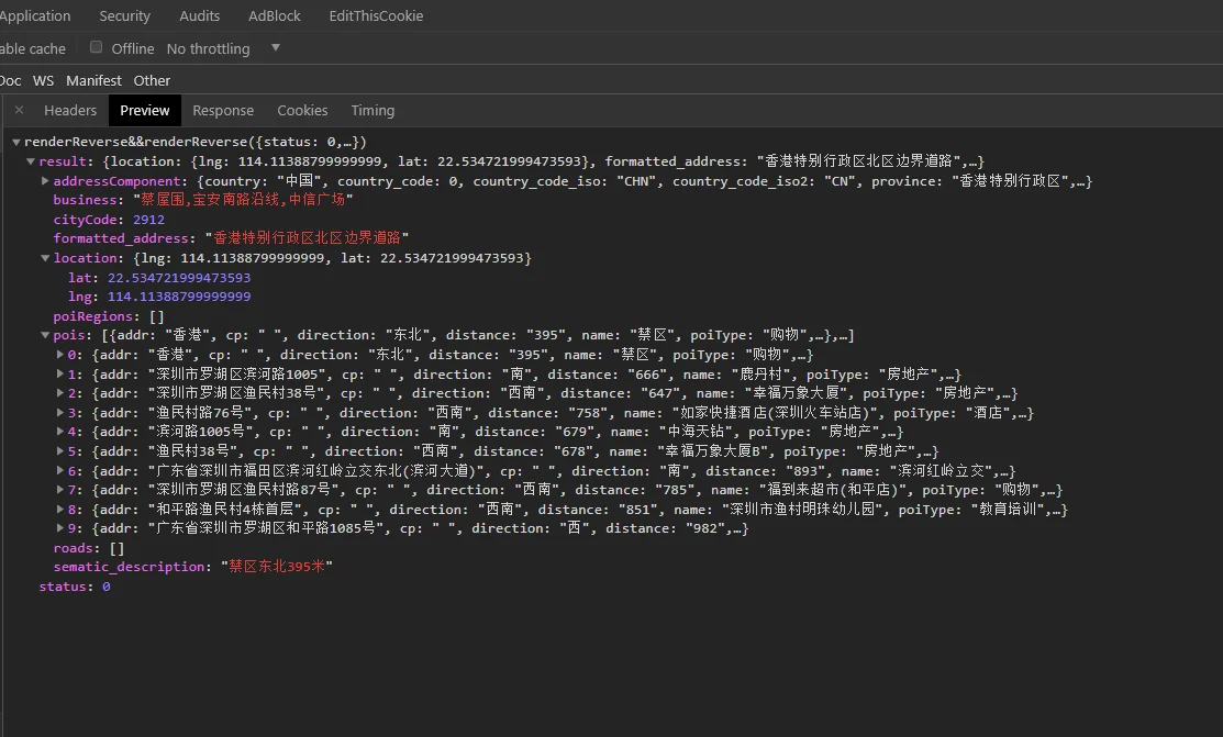
最终结果:

END
由于经纬度格式化、转换那里不是很懂,最后的定位结果(都)是偏离。。。。
Reference
http://www.cnblogs.com/shiguangliangchunshanbo/p/9745848.html
https://blog.csdn.net/oYeZhou/article/details/82012471
https://blog.csdn.net/ChenVast/article/details/81669788
https://blog.csdn.net/tyt_XiaoTao/article/details/80410279
https://www.zhihu.com/question/27043850
https://www.cnblogs.com/shijingjing07/p/7474570.html